

For journalists and researchers
Criora's climate and disaster risk data is free to read, quote and place on your own pages. Here is how, and where the data stops.
How to cite
Name Criora and link to the page you used. Every country and city page has its own citation, in a line, in APA and in BibTeX. For the world table, use this one.
Cite this page
In a line
Source: Criora (criora.com), based on INFORM, ND-GAIN and the World Bank
APA
Criora. (2026). Criora country risk scores [Data set]. Retrieved November 2, 2026, from https://criora.com/atlas BibTeX
@misc{criora_atlas_2026,
  author = {{Criora}},
  title = {Criora country risk scores},
  year = {2026},
  url = {https://criora.com/atlas},
  urldate = {2026-11-02}
} Criora's scores are under CC BY 4.0. Each source's indicators stay under that source's terms.
What you may do
Criora's country scores are under CC BY 4.0: use them for any purpose, commercial work included, as long as you credit Criora. What a source publishes stays under that source's terms, and city readings come from those sources.
Stable links
These addresses stay the same, so a link in an article keeps working.
- The country table (CSV) https://criora.com/data/country-risk.csv
- A country https://criora.com/atlas/PRT
- A city https://criora.com/atlas/PRT/lisbon
- A country's widget https://criora.com/embed/atlas/PRT
- Earth's pulse now (image) https://criora.com/pulse/latest.svg
- Earth's pulse on a given day (image) https://criora.com/pulse/2026-11-01.svg

Place it on your page
Every country and city page has the code for a small widget under Cite or embed. It is free, needs no account and always carries a link to its source.
Earth's pulse is one figure for the whole planet, as an image you can place anywhere. It renews every five minutes and is in English.
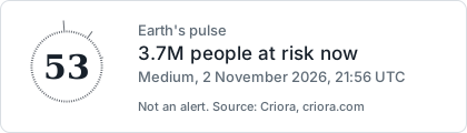
<a href="https://criora.com/?job=events&ref=pulse-image" rel="nofollow"><img src="https://criora.com/pulse/latest.svg" width="420" height="120" alt="Earth's pulse now, by Criora"></a>
What the data does not know
- A country's score describes the country as a whole. It says nothing about one town or street.
- A city's flood reading is one cell at its centre, not the whole city. Global flood maps can miss local defences and recent building.
- The earthquake hazard map dates from 1999 and reads some subduction zones low. A national code's map, where one exists, is more recent.
- People at risk are those living in an event's zone: an estimate of who may be affected, not a count of victims.
- Criora's forecast risk and Earth's pulse are our own readings, not warnings. Official warnings come from national services, and those are what people should act on.
- Projections for 2050 and 2080 depend on the scenario and the model. Quote the range and name the scenario.
- A missing value means we have no data there, not that the risk is zero.
Contact
A question about the data, or a figure you would like checked? Write to us. [email protected]